
The second in a new series highlighting Cornwall’s megalithic masterpieces. Part Two: The Stripple Stones… Cornwall’s premier stone circle fights back. Unless otherwise stated text and images © Roy Goutté.

Nearly three years ago now I made a very belated first visit to a very special stone circle erected at the southern base on Hawks Tor, north of the A30 dual carriageway on Cornwall’s Bodmin Moor… The Stripple Stones (SX 14374 75215).
On private land and just a stone’s throw away from the Trippet Stones, another stone circle on Manor Common, the Stripple Stones are a rare breed indeed as they are just one of a very small number of henged stone circles built in the British Isles but… in terms of visitation compared to others, almost forgotten about!
At the time it was one of the last of two circles I still had to visit on Bodmin’s extensive collection of moors, downs and commons and potentially the most exciting. Stone circles with a ditch and bank circling them (ditch to the inside of the bank) don’t grow on trees and I was very excited at the thought of seeing one just ten miles away from my home.
I made my way to the henge via the Trippet Stones and the track leading to the western side of Hawks Tor then made my way to the top where the views are spectacular. Rough Tor, Brown Willy and Garrow Tor dominate the skyline to the north and the A30 and Colliford lake to the south.

Nearing the summit of Hawks Tor
My first view of the circle, through the lens of my bridge camera, picked out what I’d been hoping and praying to see in the stone setting… a tri-shaped stone… and it was initially to make my day as I have reason to believe they meant something special to the circle builders over the expanses of Bodmin Moor, particularly those in sight of Rough Tor!
At that moment in time the only thing missing was my ever faithful Border Collie Chief who accompanies me on all of my moor walks, but because of the dangers of adder bites on the day (there had been 13 reported in the past month) I had left him at home.
Within minutes I was approaching the henge, but with every step I took my excitement was waning. I have a habit of doing very little research whenever I plan to visit a new site other than finding out how to reach it, so that I don’t have a pre-formed opinion in my mind based on someone else’s findings.
Stood before me was the mere shadow of a former iconic Cornish jewel in the crown. Just four ring stones left standing, the rest recumbent and either lost to nature or on the way to being so. Even the apparent tri-stone I had viewed from the top of Hawks Tor was not quite what I was expecting. The ditch and bank where still discernible were covered in reeds and showed the signs of being overrun by cattle, ponies and sheep over the years. The base of two of the surviving four uprights and also some of the prostrate stones were ringed by hollows filled with water where trodden on and scraped out by stock over the years, or the uprights used as rubbing stones. It was heart-breaking to see, but worse was yet to come!

Stone 8 in the foreground broken in three pieces and Stone 9 recumbent. Stone 10 in background just one of four left standing

Stone 10. Not quite the tri-stone as I was expecting
Unbelievably, in the past, a boundary wall had been built across about a quarter of the bank, ditch and ring setting in the NE sector! I stood there in disbelief that someone years ago had actually shown such disrespect for our heritage that this had been carried out and felt compelled to video all my findings and report them to Ann Preston-Jones the Heritage at Risk officer for the area. I feel exactly the same today and always will when faced with such wanton destruction of our heritage even though it had occurred long ago in the 19th century and the recumbent stones a victim of wandering stock and shallow stone sockets in peaty soil… always a recipe for disaster. This was a rare henged circle for heaven’s sake and should have been protected much more!

The stone hedge/bank cutting through the original ditch and bank with the ‘modern’ ditch between it and the remaining ring stones
I could go on but things are different now as a wrong is finally being put right and must now be the centre of attention and the very reason for this article.
Over the past few months I am delighted to report that a transformation has taken place and I would like to think that my reporting of the condition the circle was in at the time of my visit helped play a small part in that with Ann then championing the cause further by taking up the cudgels and by doing so set the wheels in motion to reverse the trend.
I first heard of the restorative work to be carried out on the site when Ann contacted me to ask if I’d like to help out with others on an initial GPS and geophysical survey in March 2015 to determine the original position of the ditch, bank and line of ring stones where destroyed by the boundary wall. You bet I would, and thank you Ann for the invite which was gratefully accepted.
To make things complete, I then learnt that CAU archaeologist James Gossip was to be on site as was Richard Mikulski who was to carry out the earth resistance survey. I’d worked with James before on a couple of clearances and he brings such professional knowledge and enthusiasm with him that he is a pleasure to work alongside. Richard I had not met so looked forward to learning more about his work and helping him out when called for. We were joined and assisted by Caroline, Tom, Henry and Graham on the day and all joined in with the surveying and clearance work which was carried out in good humour on a very cold and bleak Bodmin Moor day. Richard explained in full detail how the geo-fizz worked and all helpers were given the opportunity to experience it practically which was much appreciated.
It was here that I was also introduced to David Attwell of Attwell Associates (Environment & Heritage) himself a very pleasant and knowledgeable person that it was my pleasure to meet. It was David that was the first to fill me in on the details of the work to be undertaken:-
The Stripples Stone restorative works formed part of a Heritage and Archaeological Feature Protection Grant awarded to Adrian and Julie Mansfield as part of a Higher Level Stewardship Agreement. This is an agri-environment scheme administered by Natural England (DEFRA) and is a 10 year agreement. The landowners receive an annual payment in return for managing the land to meet specific prescriptions designed to benefit key habitats, species and features of interest. This includes archaeology and under the capital works programme (physical improvements required to meet the objectives of the scheme) there is an option entitled ‘Heritage and Archaeological Feature Protection Grant’. Prior to entering HLS the applicant has to complete a detailed survey of the holding and this identifies all the features of interest and their condition. Information is supplied via the county’s Heritage and Environment Record and the results of the fieldwork are fed into the formulation of the agreement helping to identify potential works. In this particular case the holdings contain some of the densest and most important monuments on Bodmin Moor and a HAP was developed by NE in partnership with the landowners, Historic England and Ann Reynolds of Cornwall Council. This included a number of elements ranging from repairs to boundaries, a beehive hut, medieval longhouse settlements and the Stripple Stones.
A brief was prepared by the landowners and NE and this was tendered in December 2014 and awarded to Attwell Associates (Environment & Heritage) in February 2015. The contract required a full project management role from applying for statutory consents to delivering the works on the ground. We put together a proposal which involved CAU (James Gossip and Ann Preston-Jones) as the principal archaeological contractor and a number of other individuals to assist in delivering the HAP package. Central to this were Adrian and Julie Mansfield given that the project needed to work alongside the farming business and they played a hands-on role throughout. Physical works initially focussed on Garrow but moved to the Stripple Stones in September 2015 following receipt of the SAM consent.
A meeting was held with Nick Russell (South West Assistant Inspector of Ancient Monuments) in May where the principles of the project were shared and challenged. A formal application was registered in July and approval received in late August. This allowed for the erection of up to 5 recumbent stones, erosion repairs along with the removal of a 19th century field boundary. This had been built through the monument as part of a late phase of enclosure for Higher Hawks Tor Farm. The HAP brief stipulated three stones to be erected and these were selected by the project team, guided by Ann Preston-Jones of HE.

James and Richard setting out in preparation for the survey

Following the geophysical survey and until my next invite with my small team of clearance workers from the TimeSeekers amateur archaeology group on the 1st December 2015, work commenced on the circle and the re-directing of the old boundary wall.
The initial works involved the removal of the boundary wall with the stones carefully dismantled for re-use as part of the realigned boundary. This took the hedge away from the inner circle approximately 3 metres to the east of the outer ditch edge. During the work two previously recorded stones (Lukis and Borlase) were found in situ at the base of the bank plus an additional stone within the hedge core which displayed signs of stone packing so could possibly have been an original ring stone. The two recorded stones showed signs of being split so could possibly be a former circle stone as the marks when aligned suggest they were originally a single slab.
The section of offending boundary wall during its removal and re-positioning by Adrian and Julie Mansfield with the help of David and Attwell Associates employees. Photo: David Attwell
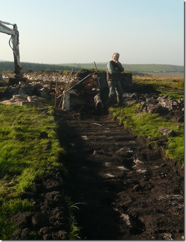
At the same time that the wall was being removed, work began to excavate the socket of one of the three stones to be raised. This failed to establish any notable ‘finds’ (a small Mesolithic flint was found in the hedge stone socket) but once again suggested that the original sockets were very shallow given the size of the stones. The recumbent stone was moved to enable this work to progress and then carefully drawn into an upright position using strops and a nine tonne swing shovel. A layer of white sand was placed to create a distinct horizon and then granite packing stones used to trig the base before successive layers of growan (rab) and granite were set and compacted to ground level. The finished surface was slightly domed to shed water before soil and turves were laid to finish the repairs. The re-erection of the further two stones followed on using a similar methodology. All were left unprotected as a key outcome of the HLS project was to restrict grazing by fencing off the area, without the public’s view or access being denied, to primarily prevent sheep and cattle poaching the ground or applying pressure on the surviving upright ring stones.

Stone 15 prior to re-erection

Nearly there… Stone 15 arises! Photo: David Attwell
The final main work involved the re-building of the new stone hedge alignment. This re-used the original stone on the inner face against the circle whilst some newer material (extracted from foundations for new farm sheds) was built on the western face. A gap was left for a gateway on the alignment identified through the field survey which suggests a further entrance opposite the known access on the western side of the circle. This new section is 90 metres in length but in total the project repaired just over 500 metres of hedgerow which included four gateways and three sheep creeps.
I have to say, without fear of contradiction, that the planning and work carried out to this point was of the highest order and all credit must go to David and his employees, Adrian and Julie Mansfield and also to James and Ann and all those working away in the background.
Then, on 1st December, under James and David’s guidance, four of the TimeSeekers clearance group (Jacqui Rukin, Caroline Lavelle, Colin Green and myself) were then asked to help out when the time came to begin a tidy-up within the circle itself and also help to re-expose a recumbent and buried ring stone that Gray had surveyed and recorded during his 1905 excavation and survey of the site. It was a bit of a puzzle to us though as to why it had not been exposed at the time but I’m sure there were acceptable reasons given as to why not!
As it was this was an easy undertaking as the stone was only some 4” to 6” under the surface and easily detectable by the slight mound above ground being visible.

Members of the TimeSeekers clearance group after the re-exposure of the long-lost ring stone. Left to right, Colin Green, Jacqui Ruken, Roy Goutté, Caroline Lavelle. On completion James re-turfed the sides to the stone to form a sloping surface which was very pleasing to the eye. Photo: James Gossip (CAU)
Further investigation around part of the circle where the clearance of other recumbent stones was felt necessary also detected two further buried ring stones thus adding more to James’ current survey although neither were re-exposed at the time.
There is something very special about re-exposing a buried stone that you know was once part of what we possibly perceive as being a ‘ritualistic or ceremonial’ monument and once likely to have been last handled by our great ancestors some 4,500-5,000 years ago! We often refer to these stones as being ‘sacred’ and I have to admit to feeling a tingle when they first see the light of day again and always hope that they are not too deep to leave exposed once recorded. They were meant to be seen and although no longer all standing are nevertheless there for our wonderment and why we as a group find great pleasure and privilege in re-exposing them at any given opportunity.
Without a doubt the discussions, site visits, planning, decision making, approvals, consents, putting out tenders etc is a lengthy process and maybe not appreciated by those who just want to get on with things, but has nevertheless got to be done. I asked James how it was for him as the leading archaeologist on site:-
Cornwall archaeological Unit were commissioned by David Atwell Associates to carry out a programme of archaeological recording at The Stripple Stones henge monument (located on Bodmin Moor at SX14374 75215) in advance of and during conservation work The Stripple Stones is a Scheduled Ancient Monument (SAM CO124) and consent was therefore required from Historic England to enable conservation repairs to specific elements of the monument on behalf of the landowners Adrian and Julie Mansfield. This formed part of a Historical and Archaeological Feature Protection Grant (HAP) included within a Higher Level Stewardship (HLS) agreement with Natural England.
This work involved the survey of the existing monument, to include standing and recumbent stones, an 1885 field boundary and topographic survey of a ploughed-down barrow to support geophysics results. The initial survey helped identify the location of a probable former entrance on the NE side of the monument which had been lost as a result of the improvement of agricultural land where enclosed by the nineteenth century field boundary bisecting the monument. The conservation work included erosion repair around selected stones, where stability was under threat. These were at risk of falling as a result of damage by livestock, compounded by the poorly backfilled excavations of George St Gray in 1905.
Removal of the 19th century hedge resulted in the discovery of two stones marked on the Borlase and Lukis plan of 1879 – although one had been moved as a result of splitting it is likely to have been left close to its original position. The two stones helped confirm the theory of an entrance on the north-eastern side, ‘framing’ a causeway across the ditch (now almost entirely backfilled) in alignment with the opposing entrance. The new hedge has been rebuilt outside the monument and respecting the arc of the ditch – a new gate now hangs in position leading the eye through the north-east entrance and through the entrance on the western side. The removal of the 19th century hedge and building of the new one, expertly constructed by Adrian and Julie Mansfield and David Atwell, has helped to re-establish the monument as a complete entity once more.
Following erosion repair and stone re-erection a team of experienced Bodmin Moor volunteers (Roy Goutte, Jacqui Ruken, Caroline Lavelle, Colin Green) were invited to take part in some further enhancement works at the Stripple Stones. Most exciting of these was the de-turfing over a peculiar ‘stone-shaped lump’ on the north-west perimeter of the monument, as visible today as it was when ‘probed’ by Tregelles in 1902 and surveyed by Gray in 1905. As suspected, removal of turf revealed a long, recumbent granite stone, exposed for the first time in hundreds of years, if not millennia.
Thanks to the efforts of the Mansfield’s, David Attwell and the Bodmin Moor Team the Stripple Stones have been transformed, giving the visitor just a sense of its original glory once again.
It was wonderful to see many of the recumbent stones that had been partially covered once again being fully exposed and hope that it is something that can be carried out on a more regular basis otherwise they will be lost to nature yet again. The new boundary wall/hedge is exceptional and matches in perfectly with the existing walling and the builders are to be applauded.
Without sounding too flowery about it, these monuments have been left for us to enjoy and marvel at by our great ancestors and should be far more respected than many currently are if our future generations are to also benefit from them. In these times of financial cuts when funding for such projects are limited, it is a great opportunity for the public to ‘get involved’ and offer their services to help clean up many of our sites as we do on Bodmin Moor. It is very rewarding and at the same time a great privilege to be able to work alongside archaeologists on monuments erected thousands of years ago! Their builders may no longer be with us but that is no excuse to let things slide and we must all jointly take over the baton and share the responsibility of becoming the custodians of these wonderful structures that we are still puzzling over after all these years.
Work is still active on the Stripple Stones and will be completed in August when a new permissive access for visitors will be available to view the monument and provided by the landowners. Adrian has kindly offered to provide access to the circle even though it lies outside of the CROW Act land. This will be achieved by an access through the fence-line to the south of the Tor which separates the two compartments.
David has informed me that in discussion with the landowners, they would prefer at the moment that we promote the route via the lane off Manor Common (NNW of the Trippet Stone Circles) which then leads onto Hawks Tor Downs where there is open access. It is still currently possible to reach the Stripple Stones via two existing gateways but involves a somewhat zig-zag route.
A detailed report will be issued at the end of the project and I will notify the Heritage Trust accordingly and pen a follow-on article which will be much more descriptive in content and the reader made more aware of the circles surroundings and setting in the landscape.
In the meantime and with the promise of warmer and dryer weather just around the corner, why don’t you all get out your maps, re-dubbin the walking boots and get out there into the fresh air to see first-hand the fantastic views from the top of Hawks Tor before descending onto the West Countries only henged stone circle… the Stripple Stones. You know you want to and all of those involved with the planning, surveying and working on the project to make your enjoyment of the circle a much nicer experience would love you to make the journey. Go safely and have fun.
Roy Goutté
North Hill
Cornwall

Harold St. George Gray’s Surveyed Plan of the Stripple Stones 1905.
Note the walling running through the north-east section of the bank, ditch and ring stones but has now thankfully been removed and re-aligned.

10 comments
Comments feed for this article
27/04/2016 at 7:03 pm
stuart dow
Wonderful article Roy !
LikeLike
27/04/2016 at 7:43 pm
Roy Goutte
Thank you Stuart, much appreciated.
LikeLike
27/04/2016 at 9:36 pm
Paul B
This is really amazing worthwhile work and has put a big smile on my face. Well done to everybody involved and well done to you Roy for reporting the mess of this special/rare site in the first place.
Just one thing – permission for five stones to be put back up but so far only three have. Are there any plans to re-erect another two? (My greedy fingers and toes are firmly crossed).
PS I’d seen something was going on up there from the A30 so really pleased to have found out that it was something wonderful.
LikeLike
27/04/2016 at 11:40 pm
Roy Goutte
Hi Paul, long time no hear.
Yes, up to five were initially approved, but the HAP brief stipulated three stones to be erected and these were selected by the project team, guided by Ann Preston-Jones of HE as mentioned.
At least we won’t have to sneak in any more looking behind us all the time eh!!
Good to hear from you…hope you and yours are keeping well.
Roy
LikeLike
28/04/2016 at 2:09 pm
Paul B
Hope you and yours are also well.
“At least we won’t have to sneak in any more looking behind us all the time eh!!” That’s brilliant news. Stones back up – brilliant news, wall moved – brilliant news, tidied up – brilliant news, stone revealed – brilliant news. It all gives me a little warm glow in these times of trouble.
LikeLiked by 1 person
11/05/2016 at 11:53 am
Bongo Fury
Joyous work Roy. I salute you. A site I haven’t had chance to visit yet but I will be there in the Summer to see (and feel) the changes and positivity you have made to this sacred space. I have a tingle going through me thinking of the good you have done. A true keeper of the stones…
LikeLike
11/05/2016 at 3:42 pm
roygoutte
Thank you BF. I can assure you that I and the clearance team have those same feelings whilst working on the stones and there will be more to come, as I have been told this very morning that a discussion took place yesterday regarding the re-erection of two more ring stones, possibly in August this year. Paul B will be glad to hear this as well.
Regards, Roy
LikeLike
14/09/2017 at 7:32 pm
Sarah Dean
We visited this beautiful site in December 2016. Having been twice in the past we were surprised and delighted at the restorative work that had been carried out, thank you Roy for having the passion and tenacity to help give this wonderful place a much needed bit of tlc. We also visited the Craddock Moor stone circle and noticed that it had looked much more tidied and well cared for. It gladdens the heart to know that there are people who care about these special places.
Best wishes Sarah
LikeLike
15/09/2017 at 9:08 am
roygoutte
Hello Sarah, thank you for your kind comments. They have actually reminded me that I am still to finish my final article on the Stripples. Seven recumbent ring stones were finally re-erected and a joy to see once again.
BTW it was TimeSeekers that carried out the work on the Craddock Moor circle and as you would have found out, a whole lot easier to find now!
We have just completed a clearance of the twin stone circles on Emblance Downs, just a stones throw from King Arthur’s Hall. The full field-notes will be appearing here very shortly.
Kindest regards
Roy
LikeLike
22/06/2019 at 6:33 pm
Roy Reed
I visited the Stripple Stones this morning. It was great to see them looking so good. Thank you for all of the work you’ve done (and all the rest of the people involved.)
I took a lot of photos which you can see here: https://www.flickr.com/photos/royreed/albums/72157709110555518/
And I’ll also be producing a 360° panorama of the circle which I’ll add to the others on my website: https://reeddesign.co.uk/panoramas/cornwall/
LikeLike